 |
National Aeronautics and Space Administration Goddard Space Flight Center |
SEARCH NASA |
 MOLA MOLA |
Mars Orbiter Laser Altimeter Observations of the North Polar Cap and Clouds on Mars
Mars Global Surveyor Press Conference
Spring Meeting of the American Geophysical Union
Boston, MA
May 27, 1998
The Mars Orbiter Laser Altimeter (MOLA) instrument collected exciting new observations of the north polar regions of Mars during Science Phasing Orbit (SPO) activities of the Mars Global Surveyor mission. Profiles of topography collected during April 1998 contain unprecedented new information about the relief of the north polar cap of Mars, as well as its surrounding features, including the expansive north polar sand seas. In addition, the instrument obtained the first direct measurements of cloud heights on Mars, with clustered cloud features appearing most prominently near the edge of the north polar cap.
During April of 1998, the MOLA instrument acquired 61 passes of data which span a region on Mars that extends from approximately 60 N latitude, over the polar cap, and down to around 15 N latitude. These profiles include over 50,000 measurements of north polar cap elevations. The spatial resolution of the MOLA profile measurements is approximately 1000 feet (330 meters) and the vertical resolution is approximately 1 foot (30 centimeters).
The MOLA profiles of the northern polar cap show the height of the Martian surface to increase sharply by about 0.5 miles (1 kilometer) above the surrounding terrain at the cap edge at a latitude of about 80 N. The elevation of the cap increases toward the pole and achieves heights above the surroundings of 1.25-1.5 miles (2-2.5 kilometers) at the highest latitude sampled, 86.3 degrees. The topographic profiles reveal striking surface topology of canyons and spiral troughs, which cut through the upper portions of the northern polar cap to depths as great as 3600 feet below the ice surface. Many of the larger and deeper troughs display a staircase structure, which may ultimately correlate with evidence of seasonal layering of ice and dust observed in Viking images of the cap obtained in the late 1970's. The MOLA data also have revealed that large areas of the ice cap are extremely smooth, with elevations that vary by only a few feet over many miles. The profiles across the ice cap will be used to understand the processes that shaped the cap, including the deposition of water and carbon dioxide, and the modification by ice flow, solar radiation, wind and mixing with dust. These observations will ultimately be used to help unravel the history of climatic variations on Mars.
MOLA also profiled vast dune fields that surround the polar cap. The dunes are typically 50 to 150 feet (~15-50 meters) tall with crest-to-crest spacings of less than a mile (~1 kilometer) in most cases. Such properties are similar to some forms of terrestrial sand dunes, especially those that form sand seas or ergs in North Africa deserts.
Below are some selected profiles across the north polar ice cap.
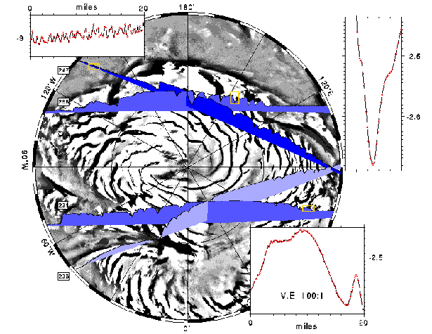
The insets at the upper and lower right show the cross-strike structure of the enigmatic spiral troughs. The inset at the upper left crosses a dune field. The red dots represent individual data points. The MOLA instrument maintained an ~99% ranging success rate during the latest observation phase. (Credit: MOLA Science Team).
Over half of the MOLA profiles revealed the presence of clouds. Reflections from the atmosphere were obtained at altitudes from just above the surface to over 9 miles (<1 to 15 kilometers). Most cloud detections were made at high latitudes, at the boundary of the ice cap and surrounding terrain. These observations represent the first direct measurement of the heights of clouds in the Martian atmosphere, making MOLA the first planetary atmospheric lidar. The measurements of the thickness and distribution of atmospheric reflections over the course of the Mars Global Surveyor mission will be used to better understand Martian weather patterns, including the transport of dust and water in the atmosphere.
Below are some examples of cloud returns in the polar region.
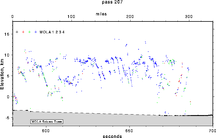
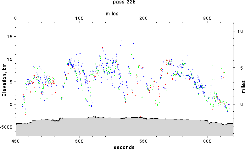
Cloud (red, green, blue) and surface (black) returns from MOLA Passes 207 and 226. The colors correspond to MOLA channel numbers. Black represents the narrowest (20 nsec) MOLA filter channel, which is optimized for detecting returns of the 8-nsec long outgoing pulses from relatively flat surfaces. Red, green and blue represent filters 2 to 4, which are wider (60, 180, and 540 nsec) and so allow for detection of return pulses that are stretched out in time. Broadening of return pulses is enhanced by interaction of the outgoing pulses with rugged surfaces or atmospheric reflectors. Note the presence of an atmospheric gravity wave in Pass 207 at a time of 640 seconds. From structures such as this it will be possible to to learn more about the dynamics of the Martian atmosphere. (Credit: MOLA Science Team)
Below is all the MOLA data that was collected in the SPO-1 orbital phase.
Warning!! There are errors in long baseline tilts due to the preliminary state of orbit reconstruction.
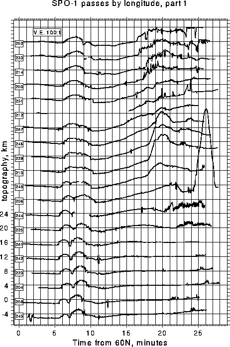
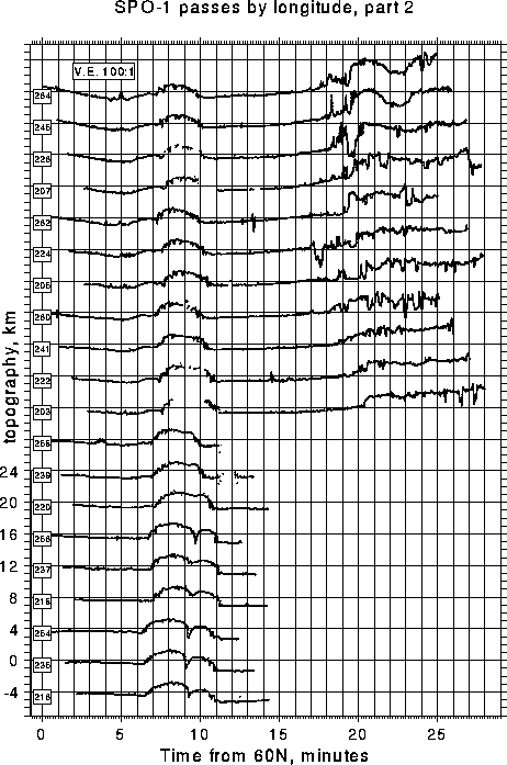
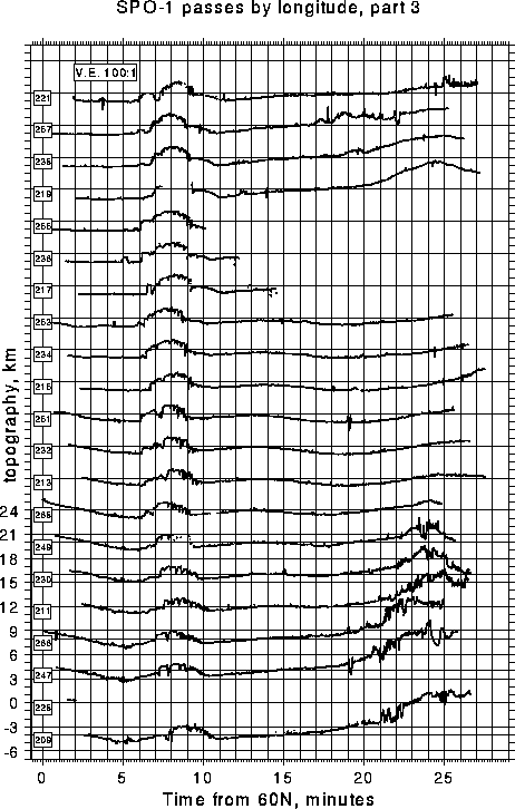
MOLA observations collected during the SPO-1 orbit, March-April, 1998. Boxed numbers at the left represent orbital passes. Shortened profiles are due to data gaps incurred during targeted imaging of the Viking, Pathfinder and Cydonia sites. (Credit: MOLA Science Team)
MOLA will collect more observations of the Red Planet during the second part
of the Science Phasing Orbit. If instrument and spacecraft performance
continues to be optimal, the data collection will continue until September 11,
1998, when aerobraking will resume to place the spacecraft in its intended
orbital vantage point around Mars in the Spring of 1999.
Return to the MOLA Science homepage