 |
National Aeronautics and Space Administration Goddard Space Flight Center |
SEARCH NASA |
 MOLA MOLA |
Results from MGS Aerobraking Hiatus Orbits
Press Release Figures from Mars Global Surveyor
Aerobraking Resumption Press Conference, November 10, 1997
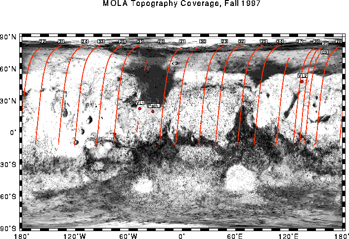
Locations of topographic profiles obtained by the Mars Orbiter Laser Altimeter (MOLA) while the Mars Global Surveyor spacecraft was in a 35-hour orbit around Mars. The tracks are overlain on a Viking image mosaic of the northern hemisphere of Mars. The MOLA instrument collected data at altitudes less than 470 miles (~750 km), which resulted in profiles of topography in the north-south direction as the instrument ranged for approximately 22 minutes during each orbit. Track numbers correspond to the number of spacecraft periapse, the point of spacecraft closest approach to Mars in a given orbit. Note that the MOLA command upload did not occur in pass 28 and almost no data was obtained along that track. (Credit: MOLA Science Team)

MOLA topographic profiles across the Amazonis Planitia region of the northern hemisphere of Mars. The profiles, obtained during spacecraft periapsis passes 22 and 31, are approximately 3200 miles (~5500 km) long and span the latitude range 80°N to 12°S. The profiles are 725 miles (1160 km) apart, yet show very similar long wavelength elevation distributions. The change in elevation over a distance nearly the width of the United States is approximately 3200 feet (1 kilometer), corresponding to a slope of approximately 1/50¡. These and other MOLA profiles confirm that the extreme flatness of the northern hemisphere shown in the first MOLA profile, obtained on periapse pass 3, characterizes Mars in the east-west direction as well as the north-south direction. The spatial resolution of the profiles is approximately 1000 feet (330 meters) and the vertical resolution is approximately 16 inches (40 centimeters). The vertical exaggeration in the plot is 100:1. (Credit: MOLA Science Team)

The MOLA instrument sampled several major shield volcanoes in passes across the massive Tharsis province in Mars' northern hemisphere. Pass 24 shows Olympus Mons, the largest known volcano of the solar system, with a diameter of 400 miles (650 km). The altimeter reveals approximately 10 miles (17 km) of relief associated with the volcano, however, because the instrument did not sample the structure across the summit the maximum height is expected to be approximately 16 miles (25 kilometers). Profile 24 delineates the collapse of the northern (left) flank of the volcano to form a rugged aureole deposit. Pass 33 shows the Alba Patera and Arsia Mons volcanic structures, the latter of which lies close to the highest point of the topographic rise that defines the Tharsis province. These two profiles show the greatest topographic elevations that have so far been sampled by the MOLA instrument. The spatial resolution of the profiles is approximately 1000 feet (330 meters) and the vertical resolution is approximately 16 inches (40 centimeters). The vertical exaggeration in the plot is 100:1. (Credit: MOLA Science Team)

This figure shows the cross-sectional relief of the Olympus Mons shield volcano as measured by the Mars Orbiter Laser Altimeter (MOLA). The profile was collected by the Mars Global Surveyor spacecraft while in a 35-hour long elliptical orbit, during periapsis pass 24. Olympus Mons, the largest known volcano in the solar system, has a diameter of approximately 400 miles. This profile missed the volcano summit, but indicates that the full dynamic height of the volcano should be about 16 miles (25 kilometers). For comparison, Mount Everest, the highest mountain on Earth, is less than half the height of Olympus Mons. The profile shows the north flank of the volcano, which has collapsed and formed a rugged aureole nearly 300 miles across. The detailed topography provided by MOLA will be used to understand the mechanism for the collapse. The spatial resolution of the profile is approximately 1000 feet (330 meters) and the vertical resolution is approximately 16 inches (40 centimeters). The vertical exaggeration in the plot is 40:1. (Credit: MOLA Science Team)

On periapse pass 33 of the 35-hour long Mars Global Surveyor elliptical orbit, the Mars Orbiter Laser Altimeter (MOLA) collected a topographic profile across the summit caldera of the Arsia Mons shield volcano. The caldera formed by collapse of the surface due to depressurization and/or evacuation of the near-surface magma storage chamber. The caldera is approximately 63 miles (100 km) across and about 3000 feet (1 kilometer) deep. For comparison the entire Los Angeles basin would fit within the structure. The detailed topography provided by MOLA will be used to constrain models which address the dynamics of magma eruption for Arsia Mons and other Martian volcanoes. The spatial resolution of the profile is approximately 1000 feet (330 meters) and the vertical resolution is approximately 16 inches (40 centimeters). The vertical exaggeration in the plot is 35:1. (Credit: MOLA Science Team)
Return to the MOLA Science homepage