The Global Topography of Mars from MOLA
Figures from the Science* Paper
*Smith, D.E., M.T. Zuber, S.C. Solomon, R.J. Phillips, J.W. Head, J.B. Garvin, W.B. Banerdt, D.O. Muhleman, G.H. Pettengill, G.A. Neumann, F.G. Lemoine, J.B. Abshire, O. Aharonson, C.D. Brown, S.A. Hauck, A.B. Ivanov, P.J. McGovern, H.J. Zwally, T.C. Duxbury, The global topography of Mars and implications for surface evolution, Science, 284, 1495-1503, 1999.
Download a PDF version of the paper.
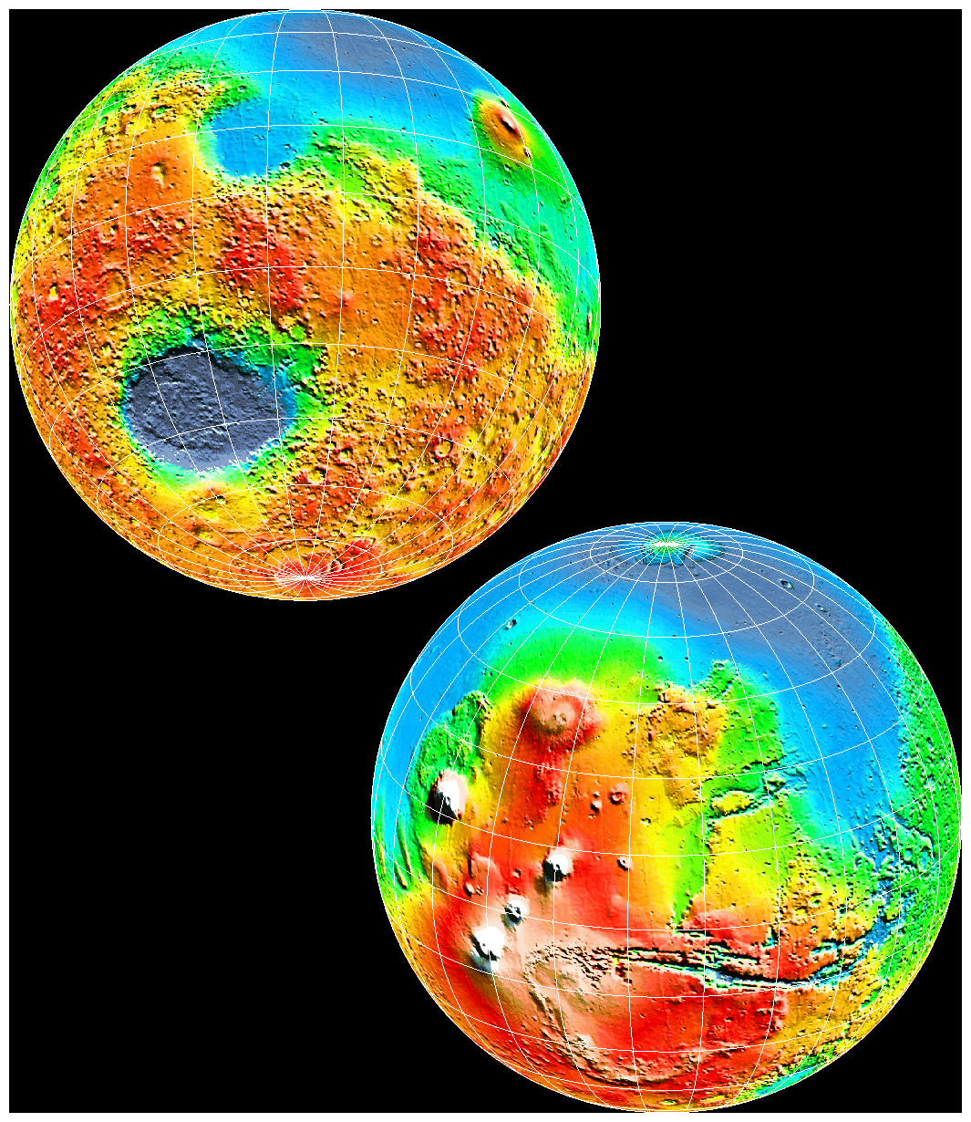
Cover image. The topography of Mars revealed by Mars Orbiter Laser Altimeter measurements taken through 15 April 1999 from Mars Global Surveyor. Shading was obtained by "illuminating" the topography from the northeast. The upper image shows the Hellas impact basin (dark blue, ~2300 km across), and the lower image shows Tharsis volcanic province and Valles Marineris. [Graphics: G. A. Neumann, Massachusetts Institute of Technology and NASA/Goddard Space Flight Center].
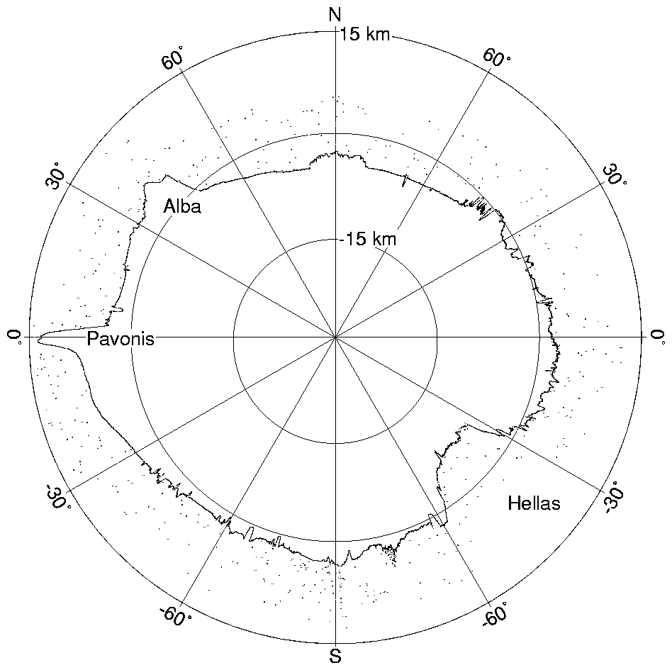
Figure 1. Global profile of Mars from MOLA crossing longitudes 52° E and 247° E. The north and south polar caps are at the top and bottom. The Pavonis Mons and Alba Patera volcanic shields, both located within the Tharsis province, appear at the upper left, and the Hellas impact basin is at the lower right. The contrast in elevation and regional topographic roughness between the northern and southern hemispheres is also apparent. The dichotomy boundary scarp can be seen at ~50° east of north. Distributed points above the surface correspond to false returns caused by solar background at the laser wavelength and represent <0.5% of the transmitted pulses. Clustered returns above the surface near the south pole are from clouds. The vertical exaggeration is 100:1. (Credit: MOLA Science Team)
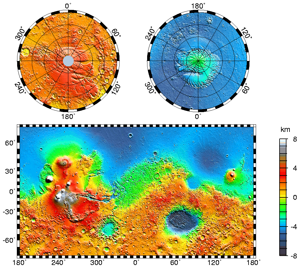
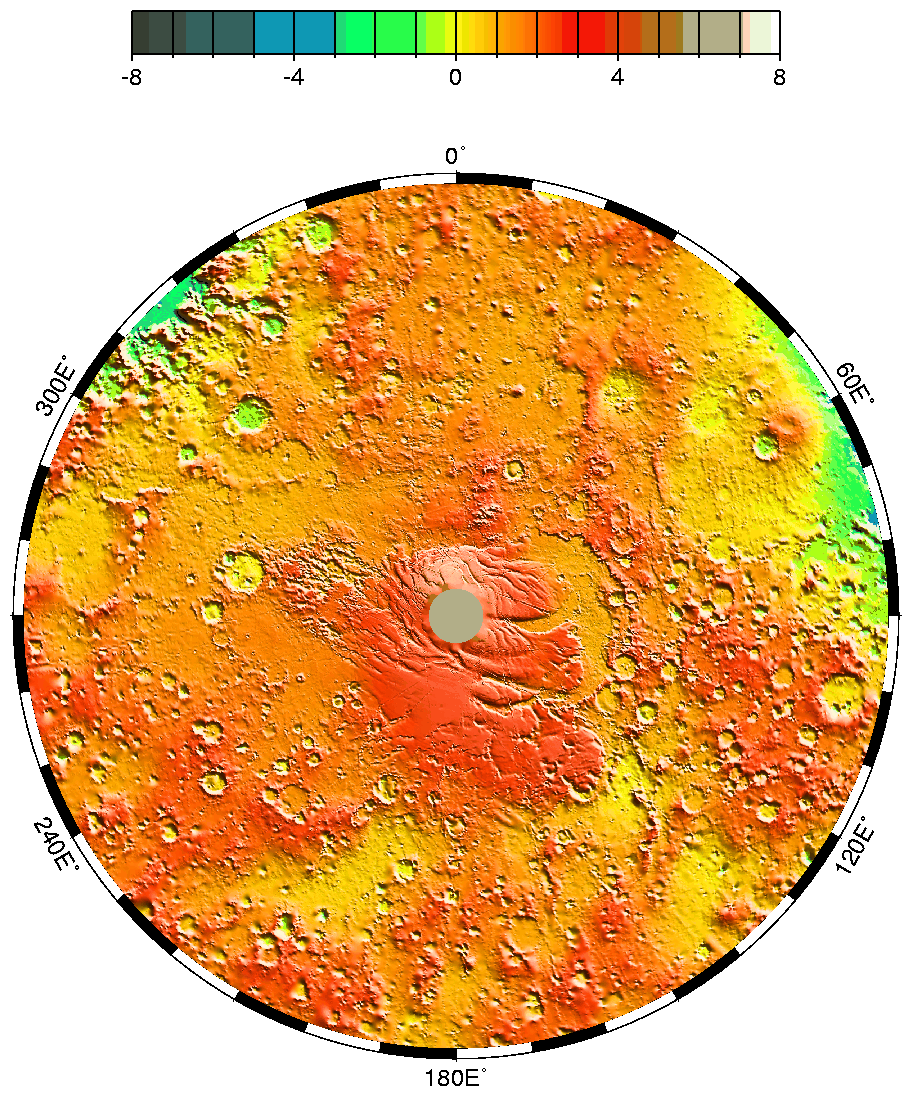
Figure 2. Maps of Mars' global topography. The projections are Mercator to 70° latitude and stereographic at the poles with the south pole at left and north pole at right. Note the elevation difference between the northern and southern hemispheres. The Tharsis volcano-tectonic province is centered near the equator in the longitude range 220° E to 300° E and contains the vast east-west trending Valles Marineris canyon system and several major volcanic shields including Olympus Mons (18° N, 225° E), Alba Patera (42° N, 252° E), Ascraeus Mons (12° N, 248° E), Pavonis Mons (0°, 247° E), and Arsia Mons (9° S, 239° E). Regions and structures discussed in the text include Solis Planum (25° S, 270° E), Lunae Planum (10° N, 290° E), and Claritas Fossae (30° S, 255° E). Major impact basins include Hellas (45° S, 70° E), Argyre (50° S, 320° E), Isidis (12° N, 88° E), and Utopia (45° N, 110° E). This analysis uses an areocentric coordinate convention with east longitude positive. Note that the color scale saturates above 8 km. (Credit: MOLA Science Team)
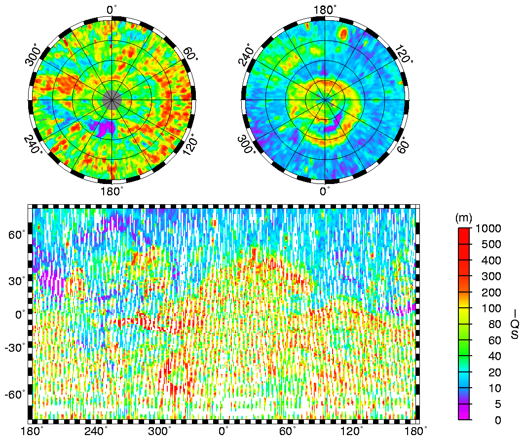
Figure 3. Interquartile scale (IQS) surface roughness (18) of Mars calculated from MOLA profiles on a 330-m baseline in a 100-km running window. The projections are the same as in Fig. 2. (Credit: MOLA Science Team)
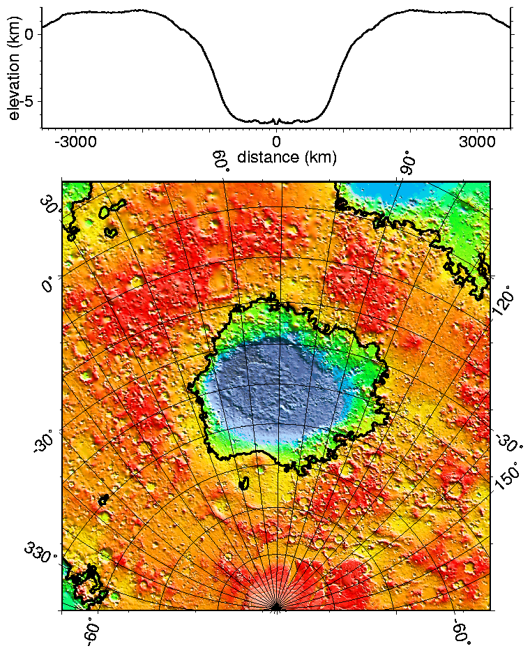
Figure 4. Regional topographic model of the Hellas basin. (Top) Azimuthally-averaged radial topography used in the calculation of infilling the basin with surrounding material postulated to have been excavated from it. (Bottom) Color-coded topography plotted in an equal-area projection with the same scale as that in Fig. 2. The black lines correspond to zero-elevation contours. (Credit: MOLA Science Team)
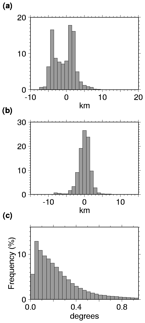
Figure 5. Histograms of (A) topography, (B) heights with respect to an ellipsoid shifted by -2.986 km along the z axis, and (C) 100-km baseline slopes. The histogram in (A) shows the distinct bimodal signature that represents the elevation difference between the northern and southern hemispheres. That in (B) shows elevations plotted with respect to an ellipsoid whose center is shifted so as to remove the effect of the COM/COF offset along the polar axis. The effect of the shift is to produce a unimodal distribution of elevations; i.e., the hemispheric difference in elevation largely disappears.
(Credit: MOLA Science Team)
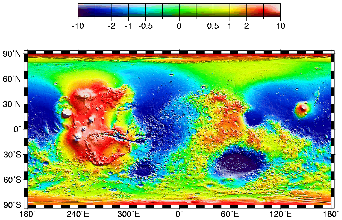
Figure 6. Map of Mars' shape with zonal spherical harmonic degree 1 (COM/COF offset along the polar z-axis axis) removed. The projection is rectangular to show topography from pole to pole. Note the general similarity in elevation between the northern and southern hemispheres. The figure highlights the two other significant components of martian topography: the Tharsis province and the Hellas impact basin. Here we have not removed shorter-wavelength topographic features, including those comprising the dichotomy boundary scarp. (Credit: MOLA Science Team)
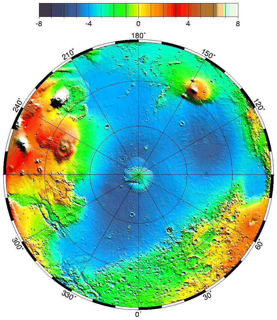
Figure 7. Lambert equal-area projection of pole-to-equator topography in the northern hemisphere. The Utopia Basin is the circular depression (in light blue) in the upper right. (Credit: MOLA Science Team)
 585 kB
Figure 8. Polar stereographic projection of topography from latitude 55° S to the pole. (Credit: MOLA Science Team)
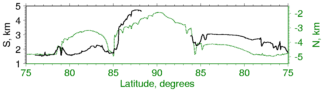
Figure 9. (Comparison of topographic profiles of the southern (solid line) and northern (dotted line) residual ice caps across longitudes 0¡ E - 180¡ E. The gaps in the middle of the southern cap profile are due to lack of coverage poleward of 87° S. The northern profile is shifted 6.7 km upward and 1° in latitude, which makes the shapes of the two caps nearly coincident. The vertical exaggeration is 100:1. (Credit: MOLA Science Team)
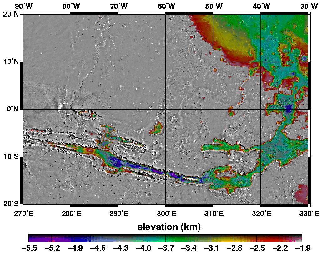
Elevations within the floor of the Valles Marineris canyon system and the adjacent Chryse outflow channels. All areas not color contoured have elevations above -1.9 km. (Credit: MOLA Science Team)
Back to MOLA home
page
Direct inquiries to: dsmith@tharsis.gsfc.nasa.gov