 |
National Aeronautics and Space Administration Goddard Space Flight Center |
SEARCH NASA |
 MOLA MOLA |
Below are maps of kilometer-scale surface roughness of Mars in cylindrical projection (top), and in polar Lambert azimuthal equal-area projection for the northern (middle) and southern (bottom) hemispheres.
The maps are composite RGB images. The median absolute values of the differential slopes at 0.6-, 2.4-, and 19.2-km baselines are used as the blue, green, and red channels, respectively. Brighter shades denote a rougher surface. For further details see: M. A. Kreslavsky and J. W. Head, Kilometer-scale roughness of Mars: Results from MOLA data analysis, J. Geophys. Res., 105, 26,695-26,711, 2000. Images should be credited to the MOLA Science Team.
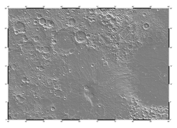
Low resolution version of shaded relief map of MC13 region of Mars showing the Syrtis Major volcano (center bottom) and Isidis impact basin (right). (Image Credit: Michael H. Carr and the MOLA Science Team)
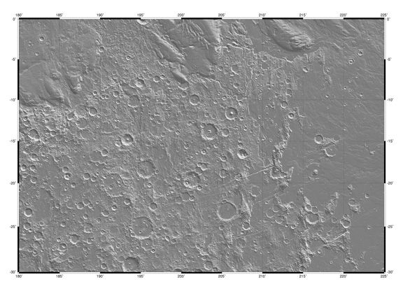
Low resolution version of shaded relief map of MC16 region of Mars showing Tharsis-related radial fractures (lower right) and the Medussae Fossae formation (top). (Image Credit: Michael H. Carr and the MOLA Science Team)
MGS Interdisciplinary Scientist Michael H. Carr, in collaboration with the MOLA Science Team, has produced a set of 30 shaded relief quadrangle maps of Mars. The maps are at a scale of 128 pixels/degree, and have been reconstructed from MOLA standard data products. The data are presented in the same format as pre-MGS USGS maps of Mars, except that they have been updated to use the MOLA coordinate system (areocentric, east-positive longitude convention). The Martian surface is divided into 30 quadrangles. Those within 30 degrees of the equator are in Mercator projection; those in the 30-65 degree latitude belt are in Lambert conformal projection, and the two poles are in Polar Stereographic projection. These quad maps are interim products and still contain minor artifacts caused by calibration errors and by interpolation where data is sparse. However, these maps have been certified by the MOLA team as conforming to MOLA standards and so we are pleased to make them available for geological studies and landing site assessment. We expect to regenerate the quads, probably Spring 2002, after the MOLA data are reprocessed with the most up-to-date IAU geodetic parameters.
The full-resolution versions of the quad maps are 2.25 meters across and can be printed map size.
Download the full resolution quad maps