 |
National Aeronautics and Space Administration Goddard Space Flight Center |
SEARCH NASA |
 MOLA MOLA |
The MOLA Science Team has just produced a quarter-degree topographic grid of Mars using data collected from the mapping orbit. A quarter-degree of longitude on Mars is 14.74 km at the equator and less elsewhere. For example, at 76° S, the latitude at which the Mars '98 Polar Lander will land this coming December, the across-track resolution of the model is 3.6 km.
Our quarter-degree model contains 118,488,105 laser-derived elevation points and it took 10 days to produce the model on a dedicated Sun Sparc Ultra60. We use "crossover analysis" to improve the accuracy of our solutions for the orbit of the MGS spacecraft, which ultimately determines the absolute accuracy of the topographic model. In crossover analysis we observe where orbit tracks cross and perform global least-squares adjustment of the spacecraft position with respect to Mars' center of mass. The current model contains 2,244,815 crossover points from 1603 orbits. The RMS mismacth of the crossovers before any other corrections is 14 meters. When we radially adjust the crossovers and throw out a small number of "bad orbits" (that contain unmodelable spacecraft maneuvers, etc.) the least mean square misfit of the model is 3.9 meters. Thus we know the global topography of Mars in a least squares sense to about 5 meters. Hats off to Greg Neumann, who performed the computation.
Note that this model does *not* include MOLA data that was collected in the Capture and Science Phasing Orbit phases of the mission. Because we have not yet re-processed the orbits for this period these data, excellent as they are, actually degrade the solution and cause unwanted fine "striping" on the maps. At some point in the future we will reprocess these orbits and add that data to the solution.
From first glance the model has the same features as the one-degree map. But the orbit striping has now been significantly reduced and in addition there is a major improvement in the resolution of smaller-scale features such as crater rims. Also, note the subtle structure in the northern hemisphere plains.
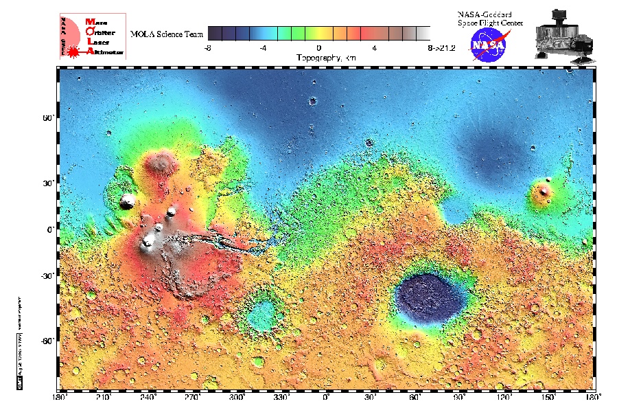
Mercator map from latitudes 75° S to 75° N. (Credit: MOLA Science Team)
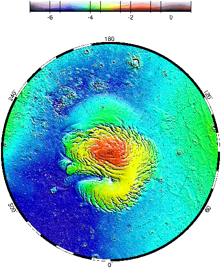
Polar stereographic projection showing the quarter-degree model from 70° N to the north pole. (Credit: MOLA Science Team)
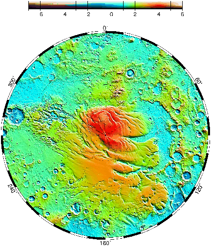
Polar stereographic projection showing the quarter-degree model from 70° S to the south pole. (Credit: MOLA Science Team)
Return to the MOLA Science homepage