 |
National Aeronautics and Space Administration Goddard Space Flight Center |
SEARCH NASA |
 MOLA MOLA |
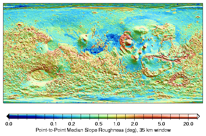
Global roughness map of Mars. The median of slopes in 35-km windows indicate the typical roughness on 300-meter baselines. The rougher nature of the heavily cratered terrain in the Southern Hemisphere is apparent, as well as that of Valles Marineris (12°S,289°E) canyon walls and the Olympus Mons (18°N,227°E) aureole deposits. The Northern Lowlands are smooth, especially Amazonis Planitia (16°N,202°E), a region to the west of Olympus Mons, were typical median slopes on these baselines are often smaller than 0.1°. A shaded relief map of the topography is overlain in monochrome. (Credit: MOLA Science Team)
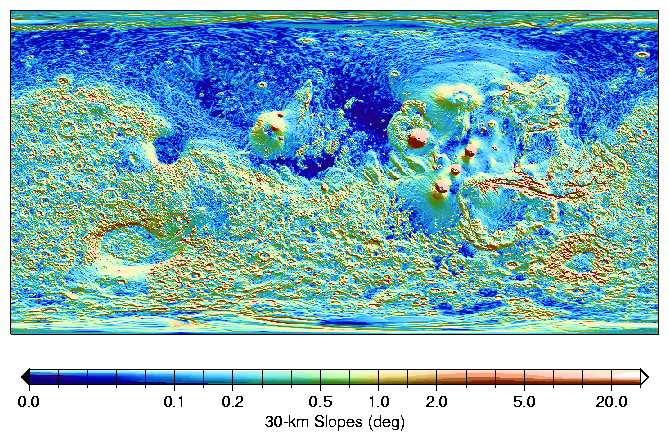
Global map of surface gradients on Mars. Absolute slopes on 30-km baselines indicate the magnitude of typical regional tilts of that scale. The Northern hemisphere is flatter than the South, and shows some linear slope breaks, for example north of Alba Patera (40°N,250°E) and the Tharsis province. The major volcanos display flanks slopes of 2.5-5°, comparable to Hawaiian shield volcanoes. The southwest rim of the Hellas impact basin appears relatively eroded, with shallower typical slopes. A shaded relief map of the topography is overlain in monochrome. (Credit: MOLA Science Team)
Reference:
Aharonson, O., M.T. Zuber and D.H. Rothman, Statistics of Mars' topography from MOLA: Slopes, correlations and physical models, submitted to J. Geophys.Res., 2000.
Back to MOLA home page