 |
National Aeronautics and Space Administration Goddard Space Flight Center |
SEARCH NASA |
 MOLA MOLA |
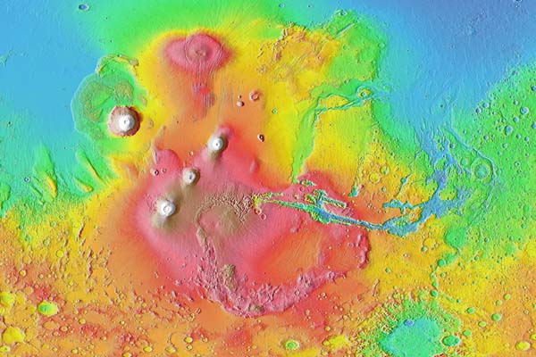
This figure shows the topography of the Tharsis province. The analysis described here shows how the formation of this massive volcanic rise may have affected the early climate and flow of water on the Martian surface. (Image Credit: MOLA Science Team)
Members of the MOLA Team used Mars Global Surveyor topography and gravity data to address loading of the lithosphere of Mars by the Tharsis rise. Tharsis is a BIG load on the surface of Mars and when it was emplaced it deformed the whole surface of the planet, just like what would happen if you punched a beach ball. By developing models, we showed that loading of Mars by Tharsis explains much of the global shape and long-wavelength gravity field of the planet. Loading by Tharsis also explains a ring of negative gravity anomalies and a topographic trough around Tharsis, as well as gravity-anomaly and topographic highs centered in the Arabia Terra region and extending northward toward the Utopia basin. We showed that the Tharsis-induced trough and antipodal high were largely in place by the end of the Noachian Epoch, the earliest stratigraphic epoch in Martian history (about 4 billion years ago).
Tilts on the planet caused by Tharsis loading also exerted control on the location and orientation of valley networks. We determined this by showing that most valley networks have azimuths that on average match the tilt induced by the combination of the response to Tharsis loading and the pole-to-pole slope of topography.
You might be wondering: why this is important? Well, the release of carbon dioxide and water accompanying the emplacement of approximately 300 million cubic kilometers of Tharsis magmas (about 10,000 Mauna Loas!) may have sustained a warmer climate than at present, enabling the formation of ancient valley networks and causing massive erosion. This is because the magmas released enough CO2 to produce a 1.5-bar atmosphere (producing a Greenhouse effect) and enough water to produce a global layer 120-m deep. So this analysis shows that Tharsis may be the factor responsible for Mars's early wetter, warmer climate.
Figures from the Science* Paper
* Phillips, R.J., M.T. Zuber, S.C. Solomon, M.P. Golombek, B.M. Jakosky, W.B. Banerdt, R.M.E. Williams, B.M. Hynek, O. Aharonson, S.A. Hauck, II, Ancient geodynamics and global-scale hydrology on Mars, Science, 291, 2587-2591, 2001.
Download a PDF version of the paper.
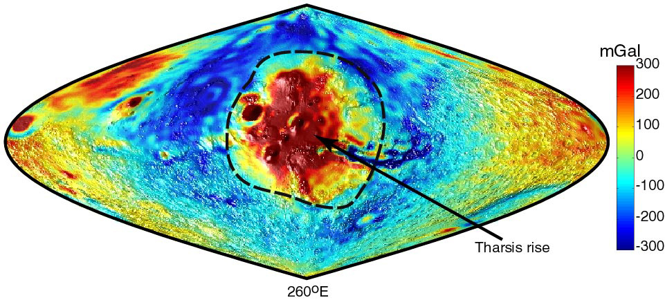
Figure 1. Gravity anomaly image draped over a three-dimensional view of topography centered on Tharsis at 260° E longitude. This and all subsequent figures are in sinusoidal projection. The prominent topographic feature in the center is the Tharsis rise and its volcanic constructs; the approximate boundary to Tharsis is shown as a dashed line. Valles Marineris extend eastward from Tharsis. Negative portions of the gravity anomaly field form a ring around Tharsis. A region antipodal to Tharsis (extremes of map near 80° E longitude) is centered on Arabia Terra, which is both a topographic and a gravitational high. (Credit: MOLA Science Team)
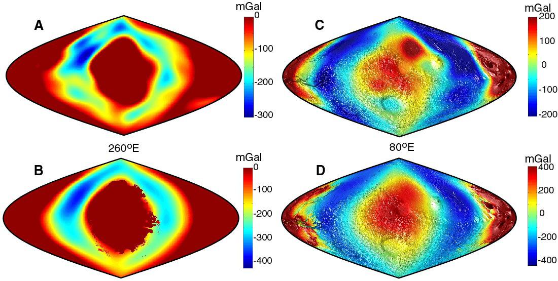
Figure 2. (A) Observed and (B) modeled negative gravity-anomaly ring around Tharsis centered at 260° E longitude. The irregular boundary around Tharsis in the model results from the fine-scale localization scheme for the load. (C) Observed and (D) modeled gravity anomalies draped over a three-dimensional view of observed topography centered on Arabia Terra at 80° E longitude. The observed gravity anomaly over Tharsis is shown in the model image. Gravity field is expanded to spherical harmonic degree l = 10 for (A)-(D). (Credit: MOLA Science Team)
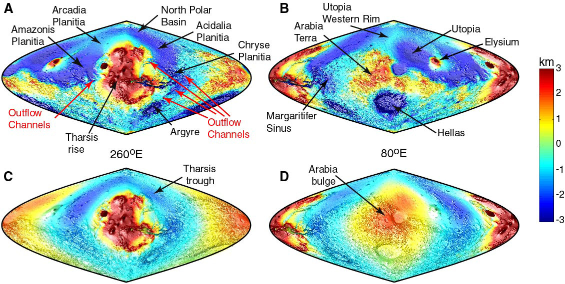
Figure 3. Martian observed topography displayed for (A) the Tharsis and (B) anti-Tharsis hemispheres compared with model topography for (C) the Tharsis and (D) anti-Tharsis hemispheres (to spherical harmonic degree l = 120). For the model, actual topography is shown in the Tharsis region, as it plus material filling the flexural depression beneath comprise the known load. All figures are draped over a three-dimensional view of shaded relief. (Credit: MOLA Science Team)
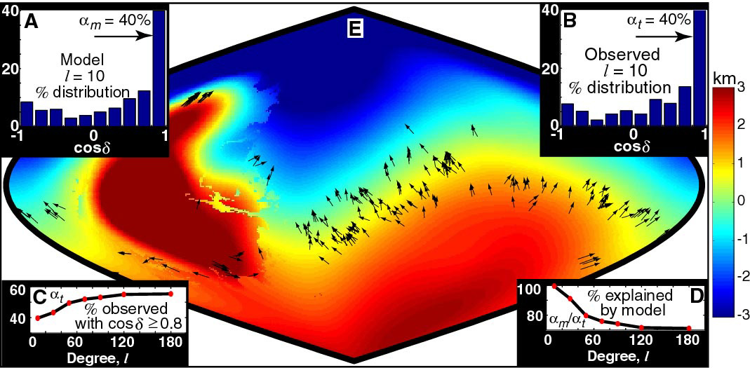
Figure 4. This figure shows the results of various fits and statistical tests to indicate that most valley networks on Mars follow a gradient consisting of the combination of the membrane response to Tharsis loading and the pole-to-pole slope in topography (Credit: MOLA Science Team)
Back to MOLA home page