 |
National Aeronautics and Space Administration Goddard Space Flight Center |
SEARCH NASA |

 MOLA MOLA |
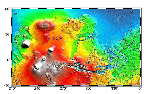
Cylindrical projection of topography in the Tharsis rise (left) and Chryse region (right). The topographic image is based on a one-sixteenth degree regional grid of all MOLA elevations collected through early August. The spatial resolution of the grid is about 3.75 km and the vertical accuracy is approximately 5 m. The color scale is the same as for our recently released quarter-degree map.
Obvious on the map are the major Tharsis volcanoes: Olympus Mons (18° N, 228° E), Alba Patera (40° N, 250° E) and the volcanic chain consisting of Ascraeus, Pavonis and Arsia montes. Note that Olympus Mons sits off to the west of the Tharsis rise and Alba Patera is separated from the main dome that contains the Tharsis montes. Note that at the high elevations of the volcanoes the color scale saturates -- those are NOT snow-capped peaks!
The new grid also shows improved detail in Valles Marineris and verifies our earlier observation that the eastern part of the canyon is about a kilometer in elevation below the mouth of the Chryse outflow channels. The westward dip of the eastern part of the canyon seems to be controlled by the intersection of pre-existing Noachian (old!) terrain with the canyon at a longitude of about 300° E. The fact that this structural control is older than the canyon suggests that the westward dip was not due to a late-stage tectonic uplift.
The map also clarifies aspects of early water transport on Mars. In the Chryse region (330° E) there is detailed structure where outflow channels debouch into the northern plains that indicates that water flowed well beyond the channel mouths into what previously appeared to be relatively featureless (from a topographic standpoint) plains. The map also shows considerable detail regarding past flow out of the Hebes Chasma (2° S, 282° E) and into the Kasei Valles (25° N, 290° E).
This figure appears in the October, 1999 issue of Physics Today. (Credit: MOLA Science Team)